Choose your language version: ![]()
![]()
![]()
![]()


GIŻYCKO ISLAND
Giżycko Island is defined as the western part of Giżycko with an area of approximately 326 hectares, the boundaries of which are marked by water bodies – three lakes and three canals.
The south-eastern border of Giżycko Island is the shore of Lake Niegocin (over 2 km). On the north-eastern side, it is separated from the town center by the Łuczański Canal (2.13 km long), connecting lakes Niegocin and Kisajno, and from the northwest, its border is the shore of Lake Kisajno (approx. 1.84 km), which is part of the second largest lake in Poland – Mamry. From the west, the border of Giżycko Island is marked by the Piękna Góra Canal (250 m long), and then by the shore of Lake Tajty (approx. 680 m).
From the south, the area of Giżycko Island is limited by the Niegociński Canal (1.20 km long), connecting Tajty and Niegocin lakes.
There are also two small lakes in the area of Giżycko Island: Popówka Mała (area of 3.20 ha) and Popówka Wielka (area 5.60 ha). The second of the lakes is connected with Kisajno Lake by a short canal (230 m long).
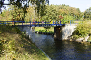
The main communication axis of Giżycko Island is the national road No. 39, within the borders of Giżycko called Stanisława Moniuszki Street, connected from the west by the provincial road No. 592, within the town limits called Fryderyka Chopina Street. Along the shore of Niegocin Lake, the railway line Olsztyn-Białystok runs via the island. The communication with Giżycko Island is possible thanks to 8 bridges: 4 bridges on the Łuczański Canal (including the historic swing bridge and a railway bridge), 2 bridges (road and rail bridge) on the Niegociński Canal, a road bridge on the Piękna Góra Canal and the footbridge on the Łuczański Canal.
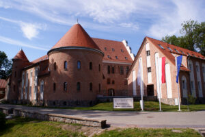
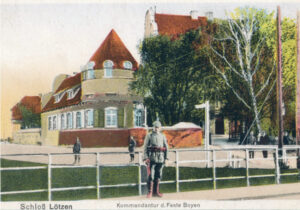
More compact development of buildings is located in the eastern part of Giżycko Island where some attractive monuments are located (the 19th-century swing bridge, the Teutonic castle which currently functions as a hotel and the Boyen Fortress), housing estates and sports grounds (stadium, tennis courts, waterpark and rope park), as well as military barracks such as the garrison headquarters of the 15th Giżycko Mechanised Brigade Zawisza Czarny.
In the north, by the shores of Kisajno Lake, there are leisure centres, including Central Sport Center – Olimpic Preparation Center. The rest of Giżycko Island is undeveloped.
The pilgrimage route – the Way of Saint James (Camino Polaco) leads along the historic Saint Bruno Street through Giżycko Island, to the sanctuary in Santiago De Compostela in Spain, as well as the local route of Saint Bruno, leading to the hill overlooking Niegocin, which is the presumed place of Saint Bruno martyr’s death. Around the Boyen Fortress and its foreground, and Saint Bruno Street there are also marked, attractive walking and cycling routes (including the Masurian Bicycle Route surrounding the Great Lakes) to which we invite you.
THE HISTORY OF GIŻYCKO ISLAND
Giżycko Island is the cradle of the oldest history of the town.
In 1935, reindeer antlers with traces of trimming were found at Popówka Mała Lake. The finding, dated back to 15 – 14 thousand years BC, is considered the oldest trace of human existence on the Great Masurian Lakes.
In the area of Giżycko Island, 11 archaeological sites were examined, of which 8 are the remains of early medieval hillforts and settlements, 2 – prehistoric cremation burials and in one case – burial of the victims of the so-called the Tatar invasion of 1657. The greatest accumulation of archaeological traces occurs in the south-eastern part of Giżycko Island – within the former castle garden (nowadays Roger Goemaere Park), furthermore, on the lakesides of Niegocin and Kisajno.
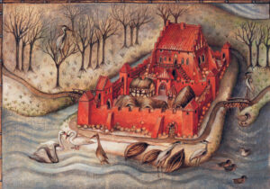
Most probably already in 1285, the first Teutonic watchtower was erected on the land isthmus created by Giżycko Island but historical sources mention the existence of the local prosecutor’s castle only in the years 1335-1341.
After the secularization of the order in 1525, the Lötzen Castle, repeatedly destroyed and rebuilt, from which the town took its name in 1612, became the seat of the princely starosts, and in the mid-19th century the headquarters of the Boyen Fortress, as well as (from 1916) the place of the museum exhibition, the so-called Vaterländische Gedenkhalle.
The oldest location of the Giżycko castle was probably different than the present one, as evidenced by the German name Althof (Old Manor) used in the 19th century and the Masurian name – Stari Zamek, defining the northern part of Giżycko Island, from the Piękna Góra Canal to the mouth of the Łuczański Canal to Kisajno.
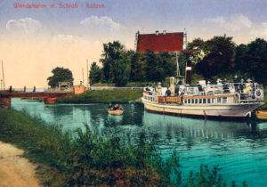
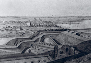
In the years 1764 – 1765, the canals: Łuczański, Niegociński and Piękna Góra were dug up which made the described area a real island.
The greatest transformation of the landscape of Giżycko Island was made in the years 1844 – 1859 with a great expense erecting an artillery fort here – the Boyen Fortress (Feste Boyen), guarding the Giżycko isthmus between the Great Masurian Lakes. The construction of the fortress and the garrison also resulted in the creation of numerous barracks in its vicinity. Boyen Fortress fulfilled its role perfectly during World War I, stopping the attack of the Russian army in August 1914 and later – in September 1914 and February 1915 – constituting a bridgehead of the victorious German counterattacks.
During World War II, the Boyen Fortress housed the camp of the intelligence organization “Fremde Heere Ost”, where captured Red Army officers (including General Andrei Vlasov) were detained and interrogated. About 40% of the area of the Giżycko Island, between Stanisław Moniuszko Street and Saint Bruno Street, is entered in the register of monuments as a valuable historical area, protecting the architectural foundation of the Boyen Fortress and its foreground.
Photographs©W.M.Darski
Niniejsza publikacja została opracowana przy wsparciu finansowym Unii Europejskiej, w ramach Programu Współpracy Transgranicznej Polska-Rosja 2014-2020.
Za jej treść odpowiedzialność ponosi wyłącznie Gmina Miejska Giżycko i w żadnym wypadku nie może być ona traktowana jako odzwierciedlenie stanowiska Unii Europejskiej, IZ lub Wspólnego Sekretariatu Technicznego Programu Współpracy Transgranicznej Polska-Rosja 2014-2020.”
The sole responsibility for the content of this publication lies with the Municipality of Giżycko and can under no circumstances be regarded as an official position of the European Union, the MA or the Joint Technical Secretariat of the Poland-Russia Cross-border Cooperation Programme 2014-2020.