Choose your language version: ![]()
![]()
![]()
![]()
List of places on the route:
GIŻYCKO GATE
CARNOT WALL
FORTRESS RETRENCHMENT
KĘTRZYN GATE
BARRAGE ARTILLERY FORT
WATER GATE
GUNPOWDER GATE
HILL OF SAINT BRUNO
GIŻYCKO GATE
As a result of the experience of the Napoleonic campaigns and the prediction of the possibility of a clash with the imperial neighbor – Russia, the Prussian staff appreciated the importance of the Great Masurian Lakes waterline as a natural barrier against the attack from the east. In order for this barrier to be fully effective, it was decided to fortify the widest isthmus between the Great Lakes in Giżycko region through which foreign armies could force their way to the west.
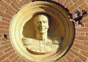
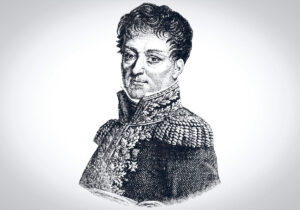
The greatest supporter of building a fortress on Giżycko Island was Field Marshal Hermann von Boyen (1771-1848), in the years 1814-19 and 1841 – the 47th Minister of War of the Kingdom of Prussia.
In 1844, Minister von Boyen solemnly laid the cornerstone for the construction of the fortress, which soon took his name – Feste Boyen.
Generals: Ernst von Aster, Karl von Grolman and Johann von Brese-Winiary worked on the construction project of a large bastion fort, who also expanded the fortifications of Królewiec. Until 1856 a six-bastion fort was built which ruled with its batteries over a narrow strip of land between the lakes Niegocin and Kisajno. At about the same time (1845-1849), the canals isolating the area of Giżycko Island in terms of communication were deepened and regulated.
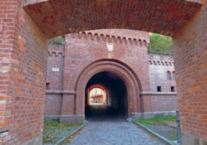
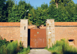
The Giżycko Gate was a representative entrance to the Boyen Fortress.
It is installed in two parts – in the mound of the counter-bank, reinforced at the top with a fortress grate, there is a brick postern with a guardhouse, which, with an arch that prevents firing straight ahead, leads to the main installation of the gate, located in the embankment of the fortress.
You will see a U-shaped caponier between the counter-bank postern and the actual gate, serving to conduct multi-directional fire along the wall and moat, and at the same time effectively preventing access to the main gate of the fortress. The ceiling of this caponier at the end of the 19th century was reinforced with concrete, and in the interwar period, rods were installed on it, used to attach the masking mesh.
The access to the main gate was additionally hampered by a small drawbridge, behind which there is a small, internal courtyard with an entrance to the caponier and the so-called the guard’s path along the inner contour of the walls. The main postern of the Giżycko Gate is secured on both sides by heavy wooden gates. In its vault there is a granite keystone with the year of completion of the building – 1848.
The Giżycko Gate leads to the courtyard of the “Sword” bastion, the main structure of which is a spacious, three-story barracks.
From the side of the courtyard, which also performs representative functions, the Giżycko Gate was endowed with decorative elements in the form of embattlement, side turrets and imitation of machicolation. On the inner frontline of the gate there is a roundel with bust of Field Marshal von Boyen.
Photographs©W.M.Darski
CARNOT WALL
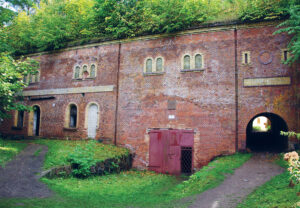
On the highest elevation of the Giżycko Island, covering an area of approx. 100 ha, earthworks and bricklaying works were carried out in the years 1844 – 1854, which were the largest investment in the entire history of the town – over 3.5 million m3 of land and approx. 101 thousand m3 of stones. After forming the ramparts of the fortress, six fortress bastions were built, the names of which were derived from the names and calls of the family field marshal von Boyen – “Ludwig”, “Leopold”, “Hermann”, “Light”, “Sword” and “Law”, caponiers, four fortress gates – Giżycko Gate, Kętrzyn Gate, Gunpowder Gate and Water Gate, three barracks, a gunpowder laboratory, two granaries, a bakery and farm and workshop buildings on the fortress’s yard.
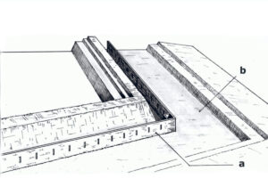
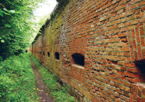
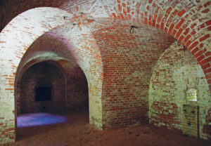
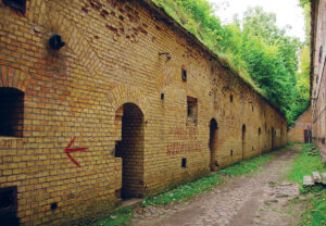
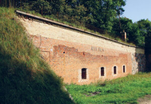
In 1855, the surrounding of the so-called fortress was completed. Carnot wall, which closed the circumference of the fortress on a total length of about 2.3 km. The wall of this type is the idea of a French general, politician and mathematician and surveyor – Lazare Nicolas Marguerite Carnot (1753 – 1823) and was first used in 1772. The idea of the Carnot wall was to set up a high, brick obstacle on the slope or at the foot of the fortress rampart in front of a ditch of so-called dry moat and a counter-bank. In order to enable firing of the fortress ditch and the counter-embankment, the wall was equipped with loopholes, behind which ran along the embankment, the so-called guards road.
The Carnot wall surrounding the Boyen Fortress is a structure made of red brick (yellow brick was used only in small sections in the south-west part), set on a high, stone pedestal. From the side of the moat, its height is 8 meters, and from the inside, by the guards road, it does not exceed 4 meters. About 900 loopholes were placed along the entire length of the wall surrounding the fortress, designed to reduce the risk of being shot by the enemy. In total, nearly 16 million bricks and 33 thousand. tons of slaked lime. In this way, the military investment became an amazing development impulse for the area, especially for the local brickworks.
The Carnot Wall was used in fortifications until around the mid-nineteenth century, so when it was completed in the Boyen Fortress, it was rather a military relic.
In the years 1860-1914, the fortress was modernized several times, forced by changing circumstances (e.g. the construction of a railway line between the fortress and Lake Niegocin, led to the loss of functionality of the Water Gate and the connection with Niegocin through the canal) and new requirements of the battlefield – mainly changes related to the range of rifled artillery weapons and the emergence of howitzers and high-explosive shells and after the First World War also with the growing importance of aviation and armoured weapons.
Photographs©W.M.Darski

FORTRESS RETRENCHMENT
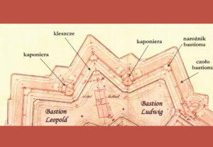
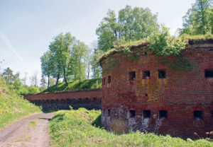
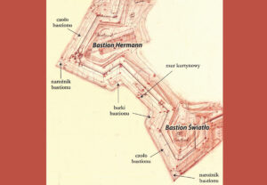
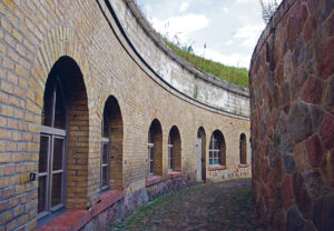
Carnot Wall, defining the outer space of two adjacent bastions – ‘Ludwig’ and ‘Leopold’, creates a model polygonal outline that is a fortress layout plan where the extended fronts of the bastions have, at the intersection point, additional defensive structures called caponiers – fortifications projecting outwards to deliver a two-way fire along the moat.
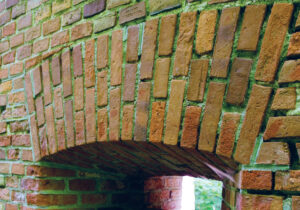
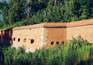
Projecting forward, between both bastions, the section of the Carnot wall, known as ‘tenaille’, separates the caponier of the ‘Ludwig’ Bastion and the caponier of the ‘Leopold’ Bastion. They are twin bastions with internal courtyards, outlined in the shape of a rounded letter V, two-storey buildings used as 7 combat chambers on each floor. The rooms of the upper storey were adapted to deliver rifle, machine gun and artillery fire and rifle fire from the lower storey only. The exit from the courtyards is provided by embankment posterns with hidden gunpowder and ammunition shelter. Both caponiers were built in 1848.
The ‘Ludwig’ and ‘Leopold’ bastions are also separated from the rest of the fortress by a high internal embankment and the only communication connection is the embankment postern, secured on both sides with heavy wooden gates. In this way, in the highest situated part of the Boyen Fortress, the so-called retrenchment was created, an autonomous element of the entire complex of fortifications, which in the event of an enemy’s forced entry into the fortress was the last point of resistance or a place to prepare a counterattack.
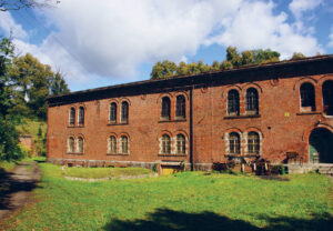
The retrenchment of the Boyen Fortress is created by the fortifications of the ‘Ludwig’ and ‘Leopold’ bastions and its center is marked by three-story barracks. The barracks of the retrenchment is a copy of the barracks from the courtyard of the Giżycka Gate but the corner basement rooms on the side of the postern were adapted to deliver fire of the entrance.
Apart from the caponiers and the barracks, there are also two infantry emergency shelters with six chambers for the crew and one sanitary and utility room on the area of the retrenchment. The ceilings of the shelters are covered with a layer of soil and the entrances to the rooms are located on the side of the embankment which minimized the possibility of being shot.
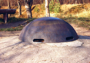
At the corner of the ‘Ludwig’ Bastion there is an emergency shelter with an observation post for tracking the foreground and directing artillery fire. Since 1893 that post was equipped with armoured Grusson dome W.T. 90. At the highest point of the retrenchment (147 m above the sea level and about 30 m above the level of Lake Niegocin) near the Giżycko Gate, in 1913, a shelter with a periscope observation post was built thanks to which the efficiently guided artillery of the Boyen Fortress could block the enemy within the radius of several kilometers.
Photographs©W.M.Darski
KĘTRZYN GATE
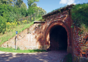
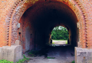
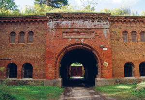
Between the bastions ‘Leopold’ and ‘Hermann’, the curtain of the Carnot wall is withdrawn, creating the passage of the Kętrzyn Gate. It is the second most important fortress gate, enabling communication of the fortress with the western part of the Giżycko Island – with a potential operational and evacuation route towards Kętrzyn, and from 1868, also with the Boyen railway station where supplies and supplements were delivered.
The Kętrzyn Gate was built in 1848, from the inside, giving its neo-gothic appearance with the imitation of the second, non-existent flooring windows. The main postern of Kętrzyn Gate was secured on both sides with heavy wooden gates and led to a small courtyard, closed from the outside with a metal gate. There are two symmetrically located entrances to guardhouses, equipped with passages to side posterns, communicating the gate and the remaining fortress area with the guards road. This solution enabled, among others firing the Gate courtyard in the event of the enemy breaking through the metal gates. At the end of the 19th century, a small canal with a drawbridge was liquidated, which operated in front of the external head of the Kętrzyn Gate.
The ravelin design of the area in front of the Kętrzyn Gate is interesting. Moving back the Carnot wall on both sides of the gate made it possible to shoot the access to it from the caponier of the ‘Leopold’ and ‘Herman’ bastions. On the counter-bank opposite the Kętrzyn Gate, two ravelin semi-caponiers were located symmetrically, additionally protecting the moat space and access to the gate.
The semi-caponier on the side of the ‘Leopold’ Bastion is a single-storey building with a compartment for powder and ammunition. The semi-caponier on the side of the ‘Hermann’ Bastion was built as a two-story construction, the upper floor of which was separated from the ground floor by a wooden ceiling.
Both facilities were built in 1852, and by 1874 they lost their defensive importance in the face of changes in technology and military tactics. Then, in the second caponier, the wooden ceiling was removed and the high room obtained in this way was adapted to the needs of the fortress chapel.
As part of the modernization of the Boyen Fortress and its foreground in the years 1913-1914, fifteen shelters were built on the Giżycko Island, operating outside the fortress walls. There were 4 infantry shelters, 4 artillery shelters, 3 ammunition shelters and 4 observation shelters with periscope positions. They were mostly blown up after 1945 but the ammunition shelters located next to the Marina of the Polish Angling Association at Popówka Wielka Lake have been preserved.
Near Giżycko Gate, the pedestrian and bicycle route branches – you can continue your walk along the walls of the Boyen Fortress or go towards St. Bruno Hill and St. Bruno Street.
Photographs©W.M.Darski
BARRAGE ARTILLERY FORT
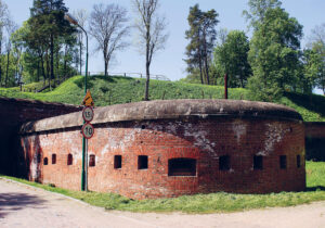
South of the Kętrzyn Gate, within the ‘Hermann’ and ‘Light’ Bastion, we can observe a model, bastion outline of the walls and the embankment, joining two projecting fortress polygons with a retracted curtain wall, secured with caponiers placed in the bastion sides.
In the courtyard of the ‘Hermann’ Bastion, the third fortress barracks is located and in the lower part nearby there is an emergency shelter for the infantry. A smaller emergency shelter was located near the shooting position at the corner of the bastion. And the main object of the ‘Light’ Bastion, apart from two emergency shelters and the observation turret, was the main gunpowder and ammunition depot of the Boyen Fortress.
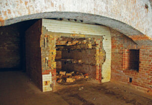
The original gunpowder depot was built here in 1852. As a result of changes in artillery technology in 1884, the depot was covered with a second brick coat and a concrete ‘cap’ protected with a layer of earth. A postern, bent at an angle of 90˚, leads to a huge room with a barrel vault. Once a two-story room (the floors were separated by a wooden ceiling), thanks to the 40-centimeter empty space between the layers of the wall, could maintain a constant temperature. Stocks of ammunition were stored here, corresponding to the two-week demand of the fort artillery, i.e. about 70,000 shells.
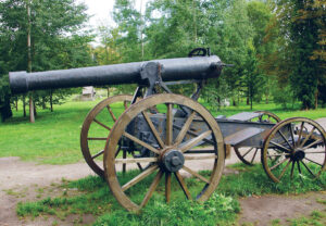
Feste Boyen, as the name suggests, was not a classic fortress in the sense of an object with a large garrison, capable of holding back a prolonged siege but only an artillery barrage fort which could block the enemy’s march through the Giżycko isthmus with its fire. Therefore, the greatest advantage of this fortification was strong artillery.
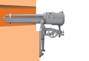
In the second half of the 19th century, the Boyen Fortress was equipped with about 100 cannons type 12 cm Kanone M 80 that could fire grenades, shrapnels and cannons at a distance of 8 km. These cannons were placed on special wedge platforms, absorbing and dispersing part of the recoil. During World War I, this type of cannon was already obsolete and used only for static defense, e.g. in the Boyen Fortress. In the 1880s however, shooting ranges in caponiers within the Carnot wall were adapted to the use of 37 mm five-barrel guns and later also 47 mm three-pounder Hotchkiss-Gruson cannons. They were used for direct fire on the foreground of the fortress and for locking the counter-bank and the moat with fire. A great advantage was the rate of fire of these cannons and the possibility of mounting them conveniently in the caponier on a gun or casemate carriage. In the cross-vaulted combat chambers of the caponiers ‘Hermann’ Bastion and ‘Light’ Bastion, at the base of the loophole, there are wall carriages for Hotchkiss-Gruson guns.
Photographs©W.M.Darski
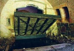
WATER GATE
The location of the Giżycko Island and the Boyen Fortress between the Great Masurian Lakes created not only defensive conditions, but also, after making the Masurian canals clear (these works were carried out at the same time as the construction of the fortress) a convenient communication and transport system. Therefore, in 1853, in the outline of the bastions ‘Light’ and ‘Law’, a Water Gate was built, which through the canal connecting the fortress with Lake Niegocin, was a supply transport line for the farm buildings located at the maidan.
The plans show that in front of the Water Gate there was the only section of the wet moat in the outline of the fort, which was accessed from one side by a canal from Lake Niegocin, and from the side of the Maidan there was an internal port. It was probably the waterway that was used to transport the elements of the granaries of Fort Lyck from the Devil’s Island in Śniardwy, which, after being dismantled and transported to Giżycko, were reconstructed on the Boyen Fortress.
The canal leading to the Water Gate and the inner port of the fortress could be used by barges with a displacement of up to 200 tons. This system ceased to function in 1868, when a railway line was built along the Niegocin lakeside, preventing the canal from further operation. Originally, the construction of a railway drawbridge was planned, but eventually the idea was abandoned and the canal was filled up.
The moat in front of the Water Gate was raised and drained, and the opening of the gate arches was significantly reduced by inserting metal gates on both sides A fragment of the canal has been preserved in the gate postern as a protective basin, the sides of which were connected by a drawbridge. Under the new conditions, the supplies reached Water Gate by a narrow-gauge railway from the Boyen railway stop in Wilkasy.
The structure of the Water Gate, built in the embankment, is connected to the fortress bakery complex. It is a complex of eleven barrel-vaulted rooms, nine of which are aligned with each other in an enfilade arrangement.
Three large furnaces, of which two have preserved, baked about a thousand half-kilogram loaves of bread per day since 1920s, also supplying the town with bread. Some of the bakery storage rooms could also be used to house recruits in the event of mobilization.
The bakery complex creates a specific lane with a shelter of the company infantry located opposite, built in the 1990s. It is a brick structure covered with a concrete ceiling and the soil bank, having eight identical rooms, connected by the enfilade corridor in the back wall. The facilities of the Water Gate, bakery and infantry shelter were connected with the guards road and caponiers on the sides of the bastions by means of two embankment posterns, secured on both sides with wooden gates and additionally, with the possibility of blocking the passage with beams embedded in special niches.
Photographs©W.M.Darski
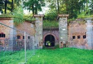
GUNPOWDER GATE
The Gunpowder Tower, located between the ‘Law’ Bastion and the ‘Sword’ Bastion, was built in 1850 as an auxiliary entrance to the Boyen Fortress from the town. Its main function was to provide food and ammunition to the troops fighting outside the fortress. From the outer crownwork, it was protected by a steel gate and a small, no longer existing drawbridge, acting as a counterweight. At the end of the 19th century, the gate and the bridge were removed and replaced with a fortress grate.
Crossbars with passages to the guards road, once protected by wooden gates, form an internal courtyard from which the entrance leads to the main embankment postern. In front of the outer crownwork of the Gunpowder Gate, there are remains of the ravelin establishment. This triangular form of fortifications is currently not legible due to the location of the amphitheater audience there. But two ravelin semi-caponiers on both sides of the gate are exposed and clearly visible, located in the counter-bank on the height of sides of the caponiers ‘Law’ Bastion and the ‘Sword’ Bastion.
On the embankments of the Gunpowder Gate, there are clearly visible remains of artillery posts with ammunition cans. 88 of those posts were prepared on the entire embankment of the fortress. At the top of the ‘Sword’ Bastion, there is also an artillery observation post, equipped with an armoured dome WT Neu type. The dome with four observation slots, with an armour thickness of 230 mm and a weight of 9,200 kg, was embedded in a three-meter layer of concrete. There are only three such domes in Poland – this one and two more in the Poznań fortress.
Near the Gunpowder Gate, within the ‘Law’ Bastion, in 1868 a gunpowder laboratory was built. It is made up of ten cross-vaulted brick rooms, seven of which are connected by passages.
The complex of the laboratory rooms has an arched outline and is separated from the stone counter-wall by a narrow corridor, also arched and open at the top.
The posterns at both ends lead to the open corridor of the laboratory. The gunpowder laboratory was built to produce the so-called black powder, made of mixing potassium nitrate, charcoal and sulfur in appropriate proportions. Black powder was very sensitive to moisture and could not be stored for a long time, so each fortress had to have facilities where it could be produced on site and armed with missiles. At the end of the 19th century, black powder was replaced by the so-called smokeless powder and the powder lab became redundant. It was converted into an ammunition depot and the missiles were transported by manually moving narrow-gauge carriages. Currently, in the restored rooms of the former gunpowder laboratory, there is a museum exhibition of weapons in the Boyen Fortress.
Photographs©W.M.Darski
HILL OF SAINT BRUNO
The Hill of Saint Bruno, formerly known as Table Mountain, was covered on three sides with the waters of Lake Niegocin. This changed in 1868, when a causeway was built on the eastern side of the hill, along which a railway line was constructed.
Fragments of early medieval pottery found on the hill indicate that a stronghold was located here, the embankments and the cultural layer of which were destroyed during the clearing of the firing field for the Boyen Fortress. The stronghold on the Table Mountain can be associated with the figure of the legendary ruler of the Old Prussian Galindians – Ysegups who was mentioned on the pages of the chronicle written by the Warmian canon Johannes Plastwich (1400-1464).
The historical record says that the oldest Prusians from Niegocin testified before the clerical commission that half a mile towards Lithuania from Leichen Castle, on Lake Niegocin there was the seat of the “great king” of Galindians – Ysegups. Assuming that the first Teutonic watchtower on the isthmus between Kisajno and Niegocin lakes was erected in the vicinity of Piękna Góra, both the distance and the direction would point to the Table Mountain as the seat of the legendary ruler.
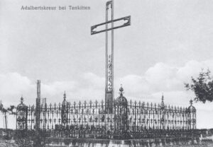
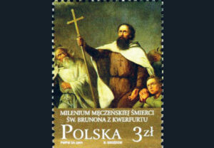
This line of thinking was probably adopted by the German theologian and church historian – Heinrich Gisbert Voigt (1860-1933), additionally (although without historical grounds) linking the figure of Ysegups with the Christianization mission carried out among the Prussians by the biographer of St. Wojciech and a friend of King Bolesław I the Brave – Bishop Bruno of Kwerfurt. This mission ended tragically on February 14 or March 9, 1009 – with the martyrdom of St. Bruno and his 18 companions from the hands of the Prussians.
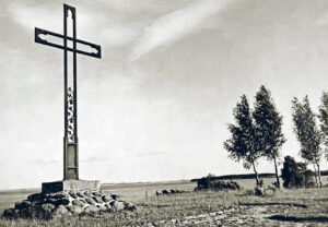
Giżycko evangelical community, based on the findings of Heinrich Voigt, erected a monument in the form of a cast-iron cross in the place of the alleged death of the missionary on Table Mountain, which is a faithful copy of the commemoration of the equally alleged place of the martyrdom of St. Wojciech – a cross from Tenkitten (now Letnoje in the Russian Kaliningrad Oblast) in Sambia. The monument was officially unveiled on October 30, 1910. The original, German-language plaque of the cross of St. Bruno is currently exhibited in the Evangelical-Augsburg church in Giżycko.
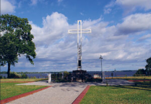
On the thousandth anniversary of the martyrdom of St. Bruno, on June 20-21, 2009, the main millennium celebrations were held on the hill with the participation of pilgrims from Poland, Germany, Lithuania, Belarus, Ukraine and Russia. The ecumenical mass, attended by the highest Catholic, Protestant, Orthodox and Greek Catholic hierarchs, was celebrated by the papal legate and the Primate of Poland – Cardinal Józef Glemp and greetings were sent by Pope Benedict XVI.
Millennium of the martyr’s death of St. Bruno was honored with a marble statue in the form of a cenotaph, placed in 2010 in front of the historic cross.
Photographs©W.M.Darski
Niniejsza publikacja została opracowana przy wsparciu finansowym Unii Europejskiej, w ramach Programu Współpracy Transgranicznej Polska-Rosja 2014-2020.
Za jej treść odpowiedzialność ponosi wyłącznie Gmina Miejska Giżycko i w żadnym wypadku nie może być ona traktowana jako odzwierciedlenie stanowiska Unii Europejskiej, IZ lub Wspólnego Sekretariatu Technicznego Programu Współpracy Transgranicznej Polska-Rosja 2014-2020.”
The sole responsibility for the content of this publication lies with the Municipality of Giżycko and can under no circumstances be regarded as an official position of the European Union, the MA or the Joint Technical Secretariat of the Poland-Russia Cross-border Cooperation Programme 2014-2020.